Abstract: Two suites of slumps from opposite margins of the Gulf of Mannar, between Sri Lanka and southern India, have met and coalesced. The “Eastern Comorin” Slump is the more coherent of the two with a length of 70 to 100 km. The “Colombo” side slump consists of two to four blocks 15 to 35 km in length. Both slump-suites decrease to the south. A paleoslump underlies the western toe of the East Comorin Slump at a depth of some 800 meters. To the south, an enlarging and deepening submarine canyon marks the area of slump coalescence

Ramasethu in Rameshwaram
Evidence: Around Rameswaram, there are raised Teri formations that supported a rich assemblage of mesolithic – microlithic tools indicating the presence of strong human habitation and activity in these areas as early as 8000 to 9000 years B.P and as recent as 4000 years B.P. On Sri Lanka side there are indications of human habitation extending to late Pleistocene (about 13,000 B.P) based on bone and fossils of human and animal form.
All these point to a flourishing human activity on both sides of Adams Bridge and probably when the sea levels were just right the link between India and Sri Lanka could have been established

Sethu samudaram
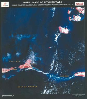
A news report date-lined Rameswaram, 15 April 2007 in the New Indian Express (page 7) noted:”… Baalu said the government and the Sethusamudram project officials had written to NASA on the Adam’s Bridge, but there has been no reply from NASA.” ISRO image gives the answer ! Why ask NASA?
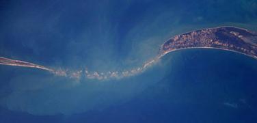
Item 1: February 2000 Report of NASA Shuttle Radar Topography Mission (SRTM) of NASA aboard space shuttle Endeavour launched in February 2000. “Sri Lanka is shaped like a giant teardrop falling from the southern tip of the vast Indian subcontinent. It is separated from India by the 50km (31mi) wide Palk Strait, although there is a series of stepping-stone coral islets known as Adam’s Bridge that almost form a land bridge between the two countries.”
Item 2: April 1966 Report of NASA exploring space with a camera by NASA “[193] Gemini XI. This photograph from an altitude of 410 miles encompasses all of India, an area of 1250 000 square miles,” GEORGE M. LOW, then the Deputy Director, Manned Spacecraft Center, NASA, notes. “Bombay is on the west coast, directly left of the spacecraft’s can-shaped antenna New Delhi is just below the horizon near the upper left. Adam’s Bridge between India and Ceylon , at the right, is clearly visible. A cloudless region surrounds the entire subcontinent. Differences in color, green near the west coast, and brown inland, delineate regions of heavy vegetation and semiarid areas.” The picture by NASA is available on the NASA website. http://history.nasa.gov/SP-168/p193a.jpg
Effect Tsunami effect: 2,60,000 lives lost Destruction of Aceh island, damage in beaches north of Chennai and Napattinam
Sea-bed has risen by about 200 m. in some regions2/3 of the aquatic life and corals devastated in the Biosphere Reserve/Marine National Parks

Tsunami effect

Tsunami effect – Before

Tsunami effect – After
Next tsunami through channel route will destroy Kerala and Tamilnadu coastline: tsunami energy will funnel through as Ram Setu barrier is dented. This serious consequence should be evaluated by a multi-disciplinary team as recommended by Rameswaram Judge.
Be prepared for a probable next tsunami. Geoscientific investigations on the active convergence zone between the east Eurasian and Indo-Australian Plates along Indonesia (GINCO I) FSSONNE cruise SO-137 Fault-lines and earthquake zones http://www.bgr.de/b322/grafik/ginco_fig1_k.png Indian plate dynamically moves northwards @6 cm. per year resulting in plate tectonics (e.g Bhuj earthquake, Aceh quake).

Sethusamudram shipping canal


